
Lot n° 34
Estimation :
200 - 400
EUR
Result with fees
Result
: 258EUR
BLAEU, G. De Zeecusten en Eislanden aent... - Lot 34 - Nouvelle Etude
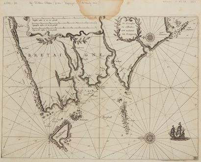
BLAEU, G. De Zeecusten en Eislanden aent westijnde van Bretaignen. Amsterdam, 1623. Black and white. Smudging at the top of the central fold. 260 x 358 mm.
Very rare nautical map from the "Zeespiegel" atlas.
Western part of Brittany from Roscou (Roscoff) to Penmarkes (Penmarc'h) with the island of
Heissant island (Ouessant) and the Seems islands (Sein island).
Title cartouche; scale cartouche: 6 Dutch miles, from 15 to the degree (11.75 cm);
7 Spanish miles, from 17.5 to the degree (11.75 cm); 8 English and French miles, from 20 to the
degree (11.8 cm). The appearance of the two cartouches is certainly of a later date than plates 4 and 5.
plates 4 and 5. Two compass roses with fleur-de-lis, one of which is on land between Audierne and
Penmarc'h. A boat at the bottom right. Map bearing the number 86 in the lower right corner.
Many rumb lines, depths here and there. Some lines for navigation
between Ushant, Molène and the mainland. The Crozon peninsula is very wide. Importance of the
rivers including the river of Conquet. Bad situation of Landerneau, but also of Le Faou or
of Fontenau, etc. Near Le Conquet, the indion : "Fenestiers".
§ Copy reproduced in Anciennes Cartes Marines de la Bretagne 1580-1800, Pl. N°6.
My orders
Sale information
Sales conditions
Return to catalogue