
Lot n° 35
Estimation :
200 - 400
EUR
Result with fees
Result
: 451EUR
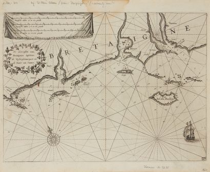
BLAEU, G. De Zeecusten en Eislanden aent westijnde van Breta - Lot 35
BLAEU, G. De Zeecusten en Eislanden aent westijnde van Bretaignen. Amsterdam, 1623. Black and white. Smudging at the top of the central fold. 258 x 355 mm.
Very rare marine map from the "Zeespiegel" atlas. Southern part of Brittany from Penmarc'h to Vannes, including Bel isle Boelijn (Belle-Ile).
Title cartouche. Scale cartouche: 8 Dutch miles, from 15 to the degree (12.5 cm);
9 Spanish miles, from 1712 to the degree (12.1 cm); 11 miles of England and France, from 2 to the degree (12.9 cm). Map from the same atlas as plate #6.
A compass rose with fleur-de-lis. A ship in the lower right corner. Map numbered 87 in the lower right corner. Many rhumb lines, depths here and there. The Quiberon peninsula seems to be connected to the mainland only by sandbanks with some low elevations.
§ Copy reproduced in Anciennes Cartes Marines de la Bretagne 1580-1800, Pl. N°7.
My orders
Sale information
Sales conditions
Return to catalogue