
Lot n° 65
Estimation :
150 - 200
EUR
Result with fees
Result
: 232EUR
THORNTON, J. A Chart of France and the Bay... - Lot 65 - Nouvelle Etude
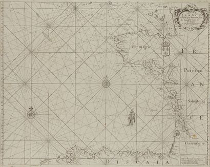
THORNTON, J. A Chart of France and the Bay of Biscaia... London, ca. 1680. Black and white. Small restored loss in upper right corner, lined with Japan paper. 427 x 550 mm.
Depicts the west coast of France to the Spanish Cape Finisterra.
Cartouche at lower right with three scales, coat of arms with three fleurs-de-lis surmounted by a crown. Two different compass roses, boat. Numerous depths in the English Channel and West Britain.
As an indication, some names: S. Mallos for Saint-Malo, Ullis haven for Perros-Guirrec,
Parsack for Portsall, Bluet for Blavet, Port-Louis Armenters for Noirmoutier.
§ Copy reproduced in C. Gaudillat, Anciennes Cartes Marines de la Bretagne 1580-1800, Pl. N°20.
My orders
Sale information
Sales conditions
Return to catalogue