
Lot n° 66
Estimation :
500 - 1000
EUR
VAN KEULEN, J. New Nautical Chart for the... - Lot 66 - Nouvelle Etude
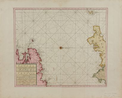
VAN KEULEN, J. New Nautical Chart for the Third Part of the Channel between England and France. Amsterdam, 1680. Beautiful contemporary col. A fine copy in period colours on strong paper with full margins. 490 x 576 mm.
Map of the English Channel from the atlas of Johannes Van Keulen taken over by his son Gérard. Map N°14. Title in Dutch, French and English. Adorned with a compass rose in the centre of the map, with compass deviation of 7.5 degrees northwest. Rhumb lines: "Roman numerals indicate the time of high tide, the days of new and full moons at the places where they occur..."
§ Copy reproduced in C. Gaudillat, Anciennes Cartes Marines de la Bretagne 1580-1800, Pl. N°19.
My orders
Sale information
Sales conditions
Return to catalogue