
Lot n° 78
Estimation :
1000 - 1500
EUR
Result with fees
Result
: 4 830EUR
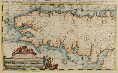
DE HOOGHE, R. Carte Nouvelle des Costes De Bretagne depuis S - Lot 78
DE HOOGHE, R. Carte Nouvelle des Costes De Bretagne depuis St. Malo jusques a l'emboucheure de la Riviere de Loire. . Amsterdam, 1693. Col. Two sheets attached. Good condition. 555 x 950 mm.
Another very decorative map by Romain De Hooge, but this one can be catalogued as both land and sea. This explains why we have already studied it in the book Old maps of the
Bretage.
Map stretched abnormally from east to west. The title indicates: "From Saint-Malo to the mouth of
the Loire". Magnificent cartouche with four views of ports: Saint-Malo, Brest, Conquerneau,
Port Louis or Blavet.
To the north, the Channel or "British Sea"; to the west, the ocean; to the south, the "Guascony" sea.
Three scales: 5 leagues of Germany, from 15 to the degree (8.9 cm); 5 leagues of Spain, from 171/2 to the
(7.6 cm); 5 leagues of France and England, from 20 to the degree (6.6 cm). Five wind roses
two of which are well marked with the words "compass error", except for the omission south of
of Penmarc'h; forty boats; two naval combats.
Numerous indications of the currents but also of the seabed, sands, shells, oysters
to the north of Cape Fréhel, or, to the south of the Cardinaux, "red sands and small stones, morcea of shells and small points shining like needles", or again, at the mouth of the Loire, "black sand made like cheese crusts and mixed with large red sand".
Some translations for coastal towns: Liondoul for Saint-Paul-de-Léon, Odegierne
for Audierne, Hoeck van t Meyland for Pointe de Meyland, Crooswyk for Le Croisil
(Le Croisic)
Finally, as an indication, it is particularly interesting to study the region between the Gulf of Morbihan and Belle-Ile for
Morbihan and Belle-Ile to realize the inaccuracy of the information obtained by
the information that the sailors were able to obtain.
§ Copy reproduced in C. Gaudillat, Anciennes Cartes Marines de la Bretagne 1580-1800, Pl. N°24.
My orders
Sale information
Sales conditions
Return to catalogue