
Lot n° 95
Estimation :
500 - 1000
EUR
Result with fees
Result
: 580EUR
VAN KEULEN, J. Marine map for a part of the... - Lot 95 - Nouvelle Etude
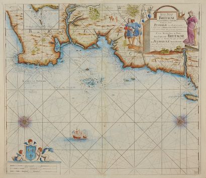
VAN KEULEN, J. Marine map for a part of the coast of Brittany from the Isle of Groa to the Roches de Penmarcke. Amsterdam, after 1699. Col. Minor foxing, paper slightly yellowed. 510 x 584 mm.
Map showing the coast from Penmarch to the island of Groix from the atlas of Johannes Van Keulen. Map N°22. Two wind roses and boats. Beautiful title cartouche decorated with characters and animals. More recent state presenting a map west of the Odet with a detail on the coast of Penmarc'h.
- C. Gaudillat, Anciennes Cartes Marines de la Bretagne 1580-1800, Pl. N°41.2.
My orders
Sale information
Sales conditions
Return to catalogue