
Lot n° 115
Estimation :
200 - 300
EUR
Result with fees
Result
: 258EUR
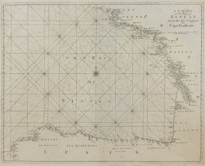
SELLER, J. A chart of the Bay of biscay from... - Lot 115 - Nouvelle Etude
SELLER, J. A chart of the Bay of biscay from the Isle Ouessant to Cape Finisterre. London, 1701-1715. Black and white. Good condition. 450 x 569 mm.
Map paginated 1 and signed lower right with interlaced letters H. Sc. With Port-Louis and Lorient.
- C. Gaudillat, Anciennes Cartes Marines de la Bretagne 1580-1800, Pl. N°53.
My orders
Sale information
Sales conditions
Return to catalogue