
Lot n° 134
Estimation :
200 - 300
EUR
Result with fees
Result
: 412EUR
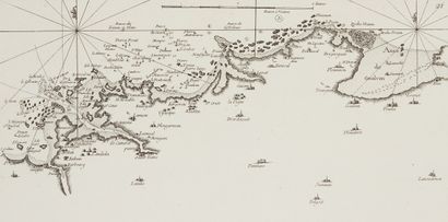
LEROUGE, G.L. Part de la Bretagne n° 16, 21 (2), 22, 23, 24, - Lot 134
LEROUGE, G.L. Part de la Bretagne n° 16, 21 (2), 22, 23, 24, 25 et 28. Paris, 1757. Black and white. Paper slightly yellowed. 197 x 321 mm.
Eight maps representing the Breton coastline by part: Cape Frehel, Goulven Cove, Ushant, Brest, Douarnenez Bay, Glenan Islands.
Maps taken from "Recueil des côtes Maritimes de France sur quatre lieues de large envi
in 50 sheets". This atlas, the first of its kind, was reprinted in 1766 by Brion, at
Desnos, with some aces. Le Rouge's maps are immediately recognizable because they have no boundaries. The
maps are seen from the ground. A pagination in the upper right corner; a scale of 2 leagues; half
fleurs de lys; no title, therefore no indication of the portion of coastline represented.
- C. Gaudillat, Anciennes Cartes Marines de la Bretagne 1580-1800, Pl. N°57.
My orders
Sale information
Sales conditions
Return to catalogue