
Lot n° 135
Estimation :
800 - 1500
EUR
Result with fees
Result
: 1 030EUR
MAGIN, Michel. Geometric map of the entrance... - Lot 135 - Nouvelle Etude
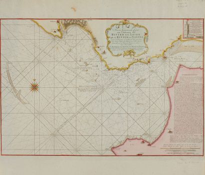
MAGIN, Michel. Geometric map of the entrance to the Loire River. 1757. Black and white. Map in 2 sheets attached on strong paper, right side a little browned. Reinforced on the reverse with strips of old paper. 666 x 998 mm.
Spectacular map by Magin Engineer of the Navy and of the Academy of Marine. A large and beautiful title cartouche, top center; a box in the corner top right,
in which one can read: "Elevation of the westernmost tower of Aiguillon", plus the text of the
the inscription above the door and a 24-foot scale of the tower.
Finally, there are numerous navigational observations in the lower right-hand section.
right-hand side. It is stated that the 1712 compass variation has not been corrected, but also that
that the soundings are in feet and reduced to the low water of the new and full moons.
Three scales: 1 marine league of 2 853 toises or 20 to the degree (19,4 cm), 1 league comune
of France of 2,28212 or 25 to the degree (15.3 cm), a scale of 2,000 toises (13.4 cm
The author of the cartouche is Juan de la Cruz Cano y Olmedilla (1734-1790), a Spanish cartographer and engraver.
engraver of Spanish origin. The engraver of the map is Guillaume Dheulland (1700-1770), publisher
engraver and designer.
At sea: magnificent wind rose. Numerous depths in feet at the edge of the dan
gers. The numerous reefs are named. Indication of the "Route given by the towers of
of Aiguillon by holding them together", but also: "Most of the ships coming from the Belle-Isle side
Belle Isle side follow this road. >>
On the coast, we notice: the Aiguillon towers, a turret near the southernmost Aiguillon tower, two forts
two forts: Mindin in the south of the Loire, La Villée Merlin in the north of the Loire, a tower at the
tower at the Pointe de Pinfour to the south of the Loire, four guardhouses; three to the north of the Loire, one to the south of the Loire, a battery at the entrance to the
Loire, a battery at the entrance of the port of Poulguen (Le Pouliguen) (Pointe de Penchatea).
§ Copy reproduced in C. Gaudillat, "Anciennes Cartes Marines de la Bretagne 1580-1800", Pl. N°58
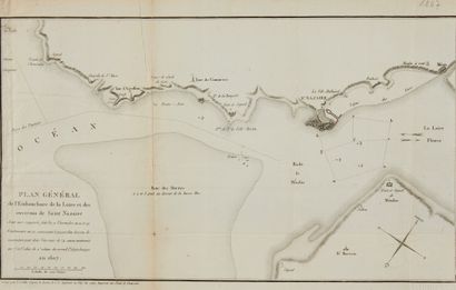
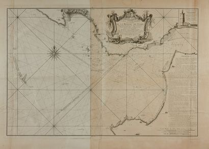
Joint: VAN KEULEN. Nieuw... Rivier de Loire. Amsterdam, ca. 1760. col. 400 x 590 mm. Copy of Magin's map./COLLIN. General plan of the mouth of the Loire and the surroundings of Saint Nazaire. 1807. 25.5 x 44 cm. Folds and cracks.
My orders
Sale information
Sales conditions
Return to catalogue