
Lot n° 136
Estimation :
1500 - 2000
EUR
Result with fees
Result
: 1 288EUR
ANONYMOUS HANDWRITTEN MAP. Map of a part... - Lot 136 - Nouvelle Etude
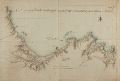
ANONYMOUS HANDWRITTEN MAP. Map of a part of the coast of Brittany from the tip of Michechelec to the tip of Plouzec sheet 2°. Ca. 1758. Nice col. of the time. Handwritten map on watercolor paper: sea in blue-green, shores in pink, buildings in red, roads are lined with trees. Pencil squares. Wrapped in paper. Small tears in the restored margins, minimal foxing. A very well preserved copy. 535 x 850 mm.
Beautiful handwritten map showing the coast between Plouzec and Michechenec (North Brittany) decorated with a 2 Leagues scale of 2400 Toises and a wind rose. The map refers to the battle of St. Cast with the date of 11 September 1758, bears the following inscription at the tip of Plouliy: "The stone at the Move where the enemy privateers slipped away in wartime". It shows the coastal defences with the trajectories of the cannon shots (in red). Also shows the "cultivated coast", the islands with their names, many mills, a justice at Pleneuf and a N.B. at Herqui. "The battle of Saint-Cast is a confrontation delivered on September 11, 1758, around Saint-Malo, during the Seven Years War. It saw an attempted British landing repelled thanks to Vauban's fortifications and the pugnacity of the local inhabitants."
My orders
Sale information
Sales conditions
Return to catalogue