
Lot n° 140
Estimation :
1500 - 3000
EUR
Result with fees
Result
: 1 932EUR
ANONYMOUS HANDWRITTEN MAP. Map of the Bishopric... - Lot 140 - Nouvelle Etude
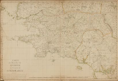
ANONYMOUS HANDWRITTEN MAP. Map of the Bishopric of Quimper or County of Cornouaille. Ca. 1760. Nice col. of the period. Handwritten map squared on paper. Ink and watercolour wash. Left edge of the map lined with a strip of old paper with a tear over 10 cm consolidated. Small lack of paper in the lower left corner. Traces of folds. 595 x 870 mm.
Large handwritten map of the bishopric of Quimper, from the island of Ouessant to St. Brieuc and Finiac (from west to east), shows the coast from Porsal (with the islands of Ouessant, Molène) to Vannes and the peninsula of Rhuis. Also includes part of the bishoprics of Leon, Treguier, St. Brieux and Vannes. Are also represented "Part of the Mountains of Arré" and the "Black Mountain" as well as the various forests represented by trees drawn with a pen. The cities are colored in pink, the roads in yellow, the rivers in green. Very detailed map with a lot of toponymy. Scale from 20 Leagues of Brittany to 2400 Toises. Oriented map. Indication : "6 degrees west of the Meridian of Paris". Warning under the title at the bottom left: "One wrote in Roman character the name of the Parishes, and in Italic Letters all the remainder: this Map is still very defective in many places, the whole only is passable; one warns even that all the words underlined are positions put at random to arrive at the true ones. In the Bishopric of Quimper all that is contained between Quintin, Loudrac, Pontivy and Rostrenen, between Chateaulin, Chateauneuf and Quimper needs correction, it is the same of the portions of the other Bishops that one finds here whose detail is very uncertain".
§ Copy reproduced in C. Gaudillat, Cartes anciennes de la Bretagne 1582-1800, Pl. N°77.
My orders
Sale information
Sales conditions
Return to catalogue