
Lot n° 150
Estimation :
150 - 200
EUR
Result with fees
Result
: 644EUR
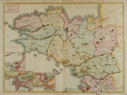
TARDIEU, P. F. Government of Brittany. Paris,... - Lot 150 - Nouvelle Etude
TARDIEU, P. F. Government of Brittany. Paris, ca. 1765. Col. Map in 4 sheets assembled, on strong paper. Small brown spots and foxing. 625 x 840 mm.
Map of the Government of Brittany, engraved by P.F. Tardieu and written by Dubuisson. Three plans at bottom left: region of Saint-Malo - Saint-Servan, port and harbour of
Brest in title, Port-Louis region - L'Orient.
§ Copy reproduced in Cartes anciennes de la Bretagne 1582-1800, Pl. N°55.
My orders
Sale information
Sales conditions
Return to catalogue