
Lot n° 157
Estimation :
800 - 1500
EUR
Result with fees
Result
: 1 739EUR
OGÉE. Geometric Map of the Province of Brittany.... - Lot 157 - Nouvelle Etude
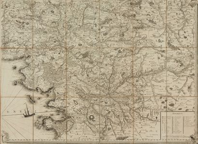
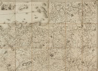
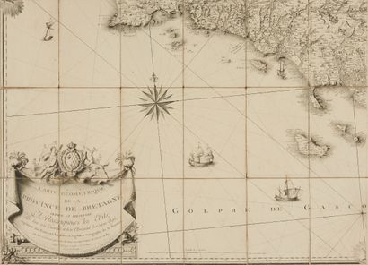
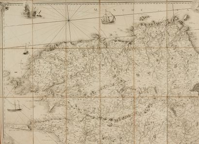
OGÉE. Geometric Map of the Province of Brittany. Paris, 1771. Black and white. Monumental map in 4 sheets, canvas-backed and folded. A fine copy. 1130 x 1570 mm.
This large map is found in different presentations: in a single sheet composed of four joined elements; in two sheets composed of two elements joined end to end; in four separate sheets; as well as maps interfaced and folded in different formats. The first maps have Ogée's signature in the corner of the title cartouche. It seems that there is only one state of this map. On the other hand, in the cartouche of the Remarks, we find differences in the address of the place of sale: - "this map is in Nantes chés the author >> - "this map is in Nantes chés" (we guess the author) with a stamp in relief "Librairie géographie Forest à Nantes, dépôt de la marine, - "this map is in Nantes chez J.Forest ainé, libraire rue J.J. Rousseau nº l*, - "since 1834, this map is in Nantes at Forest Imprimeur, libraire quai de la Fosse nº 2. The dates are not indelible. There is a watermark M 1832, Breton Frères Cie" on an unframed map Title: "CARTE GÉOMÉTRIQUE DE LA PROVINCE DE BRETAGNE" in a large cartouche in the lower left corner with the arms of France and Brittany and the motto "À MA VIE". Engraved by Nion in 1771, written by C.D. Beauvais and J. Devauce. To the right of the cartouche, a scale of 10 leagues of 2400 toises each. In the lower right corner a cartouche with the "Remarks", a scale of "5 leagues of 2400 toises each" and the wind location Only the very first maps have Ogée's signature. Remarks: a wind rose with a fleur-de-lys south of "Pont-Labbé", - about twenty ships, - two naval battles, - four fleurs-de-lys at the four inner corners of the map, - four ermines at the center of the four edges of the cae, limits of Brittany somewhat different from today. - flow of the rivers in the bay of Mont Saint-Mich- numerous roads, paths, hills, forests and valleys- very important toponymy of the coast and more particularly of "l'Abarevrak à la Baye d'Audiern".
§ Copy reproduced in C. Gaudillat, Cartes anciennes de la Bretagne 1582-1800, Pl. N°60B.
My orders
Sale information
Sales conditions
Return to catalogue