
Lot n° 169
Estimation :
300 - 500
EUR
CLERMONT, Jacques. Map of the Canal or the... - Lot 169 - Nouvelle Etude
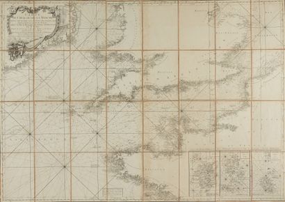
CLERMONT, Jacques. Map of the Canal or the English Channel. Paris, 1780. Black and white. Large map in segments, cloth-backed and folded. Original case a little faded. Light spotting on upper part. A fine copy. 760 x 1090 mm.
Large map of the Canal or the English Channel, engraved by Glot.
At the bottom right are, with an enlarged scale, three rectangles concerning the Channel Islands.
Channel Islands. Another cartouche at the bottom center tells us: "The time of the Tides
is indicated by Roman numerals and their variations by Arabic numerals, and the soundings and currents by an arrow. On the west and east sides of the map, the scale of marine leagues of France and England. At sea, many depths and also the characteristics of the
for example, in the Iroise Sea: "large, whitish, shiny sand mixed with barley-beard and
coral". At the extreme west of the map the following indication: "Bank according to Van Keulen called the small sole".
§ Copy reproduced in C. Gaudillat, Anciennes Cartes Marines de la Bretagne 1580-1800, Pl. N°70.
My orders
Sale information
Sales conditions
Return to catalogue