
Lot n° 171
Estimation :
40 - 60
EUR
Result with fees
Result
: 155EUR
ROBERT DE VAUGONDY, G. Map of the Government... - Lot 171 - Nouvelle Etude
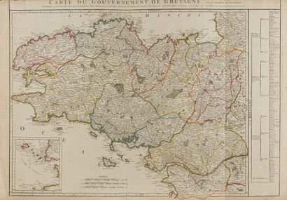
ROBERT DE VAUGONDY, G. Map of the Government of Brittany. Paris, 1758-1787. Boundaries in col. Paper slightly yellowed, traces of folds. 2 copies. 482 x 625 mm.
First state. At the bottom left a cardboard showing the islands around Ushant. Attached a copy of the second state (1768) with a new toponymy.
- C. Gaudillat, Old maps of Brittany 1582-1800, Pl. N°50.
My orders
Sale information
Sales conditions
Return to catalogue