
Lot n° 178
Estimation :
200 - 400
EUR
Result with fees
Result
: 489EUR
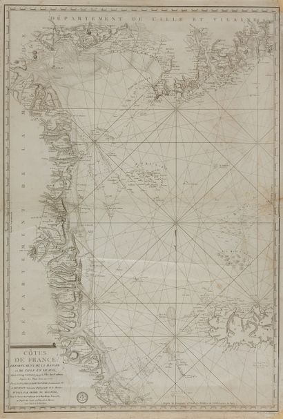
LA COULDRE LA BRETONNIERE, Louis-Bon-Jean... - Lot 178 - Nouvelle Etude
LA COULDRE LA BRETONNIERE, Louis-Bon-Jean de. Departments of Manche and Ille et Vilaine 1792, year I of the Republic. On plans surveyed in 1777. Paris, 1792. Black and white. Wrinkled along the central fold. Pale wetness. Margins reinforced. 862 x 585 mm.
With Pierre-François-André Méchain, both authors of a map entitled: "Côtes de France". "Department of Manche and Ille et Vilaine 1792, year I of the Republic. On plans surveyed in 1777. If this map seen from the sea has a great interest in its whole, west coast of the Channel and Channel Islands, let us study in particular the northern region of Ille-et-Vilaine: title at the bottom in the left corner; stamp of the Dépôt de la Marine; selling price out of the frame at the bottom right: three pounds; important toponymy of all the coast; seven guardhouses for the department of Manche; none for that of Ille-et-Vilaine; six batteries for the island of Jersey; localization of the oyster beds.
§ Copy reproduced in "Anciennes Cartes Marines de la Bretagne 1580-1800
- C. Gaudillat, Anciennes Cartes Marines de la Bretagne 1580-1800, Pl. N°72.
My orders
Sale information
Sales conditions
Return to catalogue