
Lot n° 179
Estimation :
400 - 600
EUR
Result with fees
Result
: 773EUR
CORNIC, Charles. Plan of the bay of Morlaix.... - Lot 179 - Nouvelle Etude
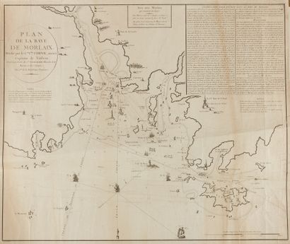
CORNIC, Charles. Plan of the bay of Morlaix. Drawn up by the C.en C.les Cornic, former Captain of ship. Ca. 1794. Black and white. Paper a little wrinkled and yellowed. Small cracks in the margins sometimes consolidated. 583 x 720 mm.
Plan showing the bay of Morlaix drawn by Captain Charles Cornic. Engraved by Bouclet, written by Hérault. Long text in the upper right corner: "Instruction for entering the bay of Morlaix". The map shows in particular the channels: Treguier or Cornou channel, Grand chenal, Léon channel and a channel between the coast and Batz island which is not named. Buildings visible from the sea and serving as landmarks are represented, such as the village bell towers: the Great Tower of Saint. Paul-de-Léon, the two towers of the cathedral of Saint-Paul and the Ursulines, the Tour de la Lande (lighthouse of La Lande), also appear a mill, houses, chapels and villages. Ships follow the channels towards the bay. The map is oriented and the traditional fleur-de-lys indicating the north is replaced by a Phrygian cap. The scale is in nautical leagues and in toises.
Charles Cornic, a privateer from Morlaix, was also the cartographer of the Bay of Morlaix and the channel of the island of Batz. Charged by the committee of public salvation to reorganize the coastal defense, for 5 years, he worked hard to map and improve the marking of the Bay and the channel of the island of Batz. He also financed the installation of beacons and towers in the most dangerous places on the coast.
My orders
Sale information
Sales conditions
Return to catalogue