
Lot n° 196
Estimation :
300 - 500
EUR
Result with fees
Result
: 644EUR
LENGLET DU FRESNOY / ELIE DE BEAUMONT. (Geological... - Lot 196 - Nouvelle Etude
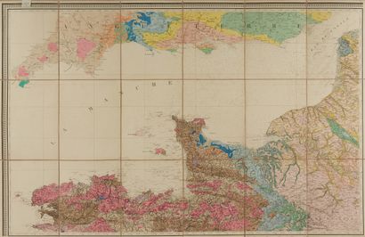
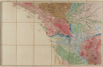
LENGLET DU FRESNOY / ELIE DE BEAUMONT. (Geological map of Brittany). Paris, 1840. Printed in colours Map in 2 sheets not joined in segments, canvas-backed and folded. Total dimension : 1400 x 1120 mm. 700 x 1120 mm.
Very large geological map of Brittany in 2 sheets, part of the "Carte géologique de la France".
"Geological map of France, executed under the direction of M. Brochant de Villiers, general inspector of mines, by MM Dufrénoy and Élie de Beaumont, engineers of mines. Begun under the administration of M. Becquey, director general of the Ponts et Chaussées and the mines. Completed in 1840, Count Jaubert being Minister of Public Works, Mr. Legrand under-secretary of state in the same department.
In 1822, Brochant de Villiers was given the task of drawing up a geological map of France, based on the English map, with the help of two young mining engineers, Dufrénoy and Élie de Beaumont. It was presented to the Academy of Sciences on 20 December 1841.
My orders
Sale information
Sales conditions
Return to catalogue