

Lot n° 201
Estimation :
200 - 400
EUR
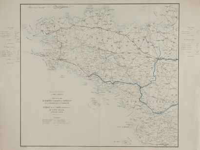
STATE-MAJOR. Map of the line from Nantes... - Lot 201 - Nouvelle Etude
STATE-MAJOR. Map of the line from Nantes to Lorient and Chateaulin with a branch line to Napoleonville. Paris, ca. 1867. Boundaries in old col. Autographed map in two colours. Annotation in pen : For a trip to Brittany. A fine copy. 675 x 750 mm.
Map for the Compagnie du Chemin de Fer de Paris à Orléans; extract from the assembly map of the Etat-Major. Scale 1/380 000. On each side, indication of railways and dirt roads. Drawn by A. Masses; Autographed in two colours by Régnier and Dourdet, 8 Pge S.e Marie, Paris. Joint: 4 maps by Chaix.
My orders
Sale information
Sales conditions
Return to catalogue