
Lot n° 228
Estimation :
1000 - 1500
EUR
Result with fees
Result
: 1 803EUR
BEAURAIN, le Chevalier de. Topographical... - Lot 228 - Nouvelle Etude
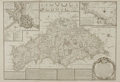
BEAURAIN, le Chevalier de. Topographical map or very particular description of the isle of Belle Isle divided into its four Parishes. Paris, 1760. black and white. A very fine copy on strong paper, with the boundaries of the parishes delineated in red at the time. 485 x 690 mm.
Rare map of Belle-Île entitled "Topographical map or very particular description of the isle of Belle-Isle divided into its four Parishes Done after several others which have been raised on the Places among others of a large one which served to make the Terrier, which gives the most detailed Connoissances, joined to a large speech relating to these same details One finds there also on the Coast the Batteries which were made to be useful for its deffence and reduced on a larger point placed on the plate cy deßus it still contains the Chronological, Historical and Geographical History of this Island by the Author cy après named. Dedicated and presented to the King by His very humble, very obedient and very faithful servant and subject Chevalier de Beaurain Géographe Ordinaire du Roy et Ci devant de l'Education de Monseigneur le Dauphin Avec Privilege du Roy 1761. Includes a beautiful title cartouche, a historical, cronological and geographical description of the Isle.., a carton with a plan of the citadel of Belle-Isle, a carton with a map of the coasts of Brittany and a band with the "Plans of the principal Batteries made for the deffence of the coast of Belle-isle". "The Capture of Belle-Île-en-Mer is the name given to the British expedition in which the French island of Belle-Île-en-Mer was captured in 1761, during the Seven Years' War."
My orders
Sale information
Sales conditions
Return to catalogue